It’s like Ontario’s Rainbow Country Tourist Region was created for couples. The southern boundary of Rainbow Country is the City of Parry Sound, about three hours north of Toronto on Highway 69. At the end of the drive – or rainbow – are some golden trails.
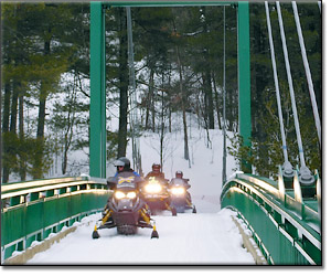
There are many attractions in this region, but the newest and biggest are two impressive snowmobile bridges spanning the French and Pickerel Rivers. It seemed wherever I was last winter, someone would ask if I had seen the bridges.
North of the bridges you’ll enter the legendary Broder Dill trail system. It had been years since I had ridden these trails which were great in the early ‘90s and are even better today. Broder Dill’s trails are part of the giant STP (Sudbury Trail Plan) system and it has been one of Ontario’s premiere riding destinations for over a decade.
If lakes aren’t your idea of fun, the trail system also allows you to travel around the waterways. However, the most frequently used lakes are well marked and the linking trails lead only to the safest entries and exits.
No man will deny, when traveling with your better half, clear directions are very, very important. There are plenty of easy-to-read maps and the trails are extremely user-friendly here.
Located just north of Lake Wanapitei is Wolf Mountain and on a clear day the view is incredible. The landscape goes on forever and gives you an idea of how rugged the Canadian Shield really is. The region is huge and in five days you can’t see it all so you’ll definitely have to come back again.
For information on Rainbow Country, call 800-465-6655 or visit RainbowCountry.com
Story by: John Arkwright


